PIANCOGNO
The municipality of Piancogno was established with a Decree of the President of the Republic of 3 December 1962 – published in the Official Gazette of 29 January 1963, and is the most recent municipality in Valle Camonica. It is made up of 3 hamlets on the right bank of the Oglio river: Piamborno and Cogno are located on the valley floor and partly on the foothills; the Annunciata is located on the mountain side in a panoramic position and is full of testimonies of art and devotion. Piamborno, where the town hall is situated, is the main village, with about 3000 inhabitants.
BETWEEN PAST AND MODERN TIMES
Until the 1960s, the municipality was based on an agricultural economy, with the exception of the hamlet of Cogno where, at the beginning of the 20th century, the Olcese cotton mill was built. In the last fifty years, the economy of Piamborno has been transformed: from agricultural it has become mainly artisanal and tertiary and the urban characteristics of the town have also changed.
The foothills of Piamborno and the terraced slopes of the Annunciata are, from documents dating back to the Middle Ages, areas suited to the cultivation of vines. Particularly valuable is the Lanzato wine, obtained from the vineyards located in the locality of the same name.
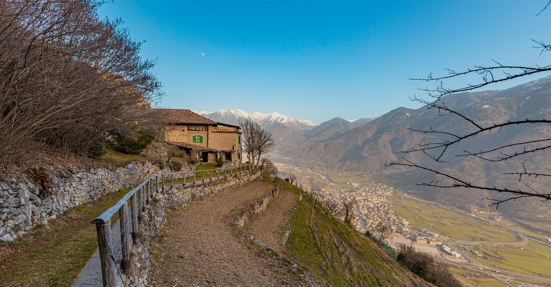
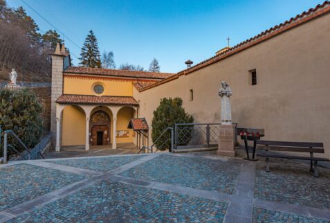
The hamlet of Annunciata is located in a privileged position with an incredible 360-degree panorama of the Valle Camonica. This locality takes its name from the convent – sanctuary dedicated to the Annunciation, now managed by the Capuchin Friars.
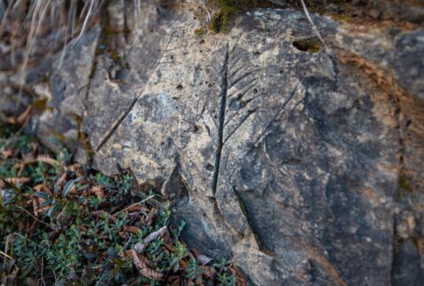
The whole territory surrounding the convent hosts a considerable quantity of graffiti which are inserted, with their own specific features, in the vast heritage of rock engravings of Valle Camonica.
ADMINISTRATIVE AND GEOGRAPHICAL ASPECTS
Among the municipalities of Valcamonica, Piancogno is the one that was formed more recently (in 1963), with the aggregation of the hamlets of Annunciata, Pian di Borno and Cogno, which previously formed part of Borno and Ossimo.
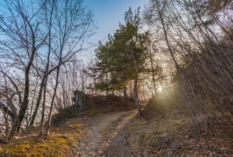
It is located in the lower Valle Camonica to the right of the Oglio river, al hulìf (on the sunny side): in particular, Pian di Borno, which is the most populated nucleus, extends over the foothills and the wide flat valley floor; Cogno is mainly positioned close to the mountain side and the Annunciata is located upland at an altitude of 700 m. In the past, the connections between the three hamlets and with the centres of Ossimo and Borno took place (and still partially take place) through a network of municipal roads including the bià dè le ólte (the road of the vaults) and the bià dè le icc (the road of the vineyards), which lead into the ancient Roman Via Valeriana located halfway up the mountainside.
HISTORICAL-ECONOMIC ASPECTS
The discovery of a Roman tomb – with a golden ring inside – which occurred during the excavations carried out for the construction of the current parish church of Pian di Borno, the discovery between the Davine and Trobiolo valleys of the remains of masonry structures, archaic houses and rock graffiti dating back to the Celtic and Roman ages, the terraces created with dry stone walls, the cadèi (small rural buildings) and the farmhouses scattered on the slopes of the mountain are the testimony of a millenary human presence.
The specific geomorphological characteristics and the different position have contributed to differentiating the history, economy and culture of the three hamlets.
PIAMBORNO
The foothills of Pian di Borno are particularly suited to viticulture, widely practiced not only in the past but also nowadays. In the first half of the 19th century it was the village in Valle Camonica with the largest quantity of grapes harvested and the wine produced was highly appreciated; during the 20th century, the first company in the valley was established to bottle and label ‘Lanzato’, the wine produced in the area of the same name. Furthermore, the wide flat expanse – which extends as far as the Oglio river – constitutes one of the few areas of Valle Camonica where agriculture is still flourishing and allows the activity of three farms that raise cattle for the production of milk. In the past there was a rich variety of crops (maize, wheat, vegetables, fruit trees, willows, mulberry trees for breeding silkworms…), while today forage crops prevail.
The hamlet of Glazel is near the ancient parish church of San Vittore, a group of buildings arranged around a large rectangular courtyard. Thanks to the recent conservative restoration, the complex maintains the original structure of the second half of the nineteenth century, built by Paolo Glazel, belonging to one of the wealthiest families in Valle Camonica at the time, owner of a considerable amount of houses, land and woods not only in Pian di Borno but in various other villages in the valley. Adjacent to the stately home, there were rural buildings and nearby also a spinning mill (subsequently demolished), as it was the site of a farm managed by the manor; moreover, in the office located on the ground floor of the stately home, contracts with the peasants were stipulated on 11th November every year. Many families, of Piamborno who owned neither houses nor land were tenant farmers of the Glazels and, in a few cases, also of other landholders. This situation lasted until the 1960s, when the Glazel family disappeared and the Passerini took over.
ANNUNCIATA
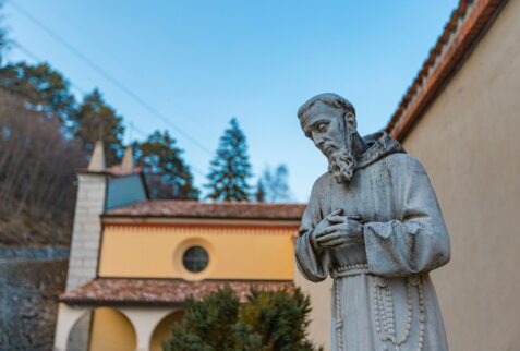
The center of the Annunciata consists of the Capuchin convent and the adjacent church dedicated to Mary, while the houses scattered around are now largely depopulated. The isolated position, the charming natural environment and the view of the valley that ranges from Pizzo Badile to Lake Iseo are the basis of the choice made by the founder, Blessed Amedeo Meneses de Sylva, in the second half of the fourteenth century. The presence, near the convent, of a place traditionally called Predù dè l’altar (large stone of the altar) and of a depiction of the god Kernunnos on a rock, found among the many graffiti existing in the area, and of a country church older than the convent, suggest that the place has had a cult-religious function since ancient times.
COGNO
COGNO In the hamlet of Cogno, despite the building renovations that have been carried out, traces of the industrial village that took shape around the Olcese cotton mill during the twentieth century can still be seen. In fact, alongside and in support of the factory, various buildings were built (houses for workers and employees, boarding school, kindergarten, new church, after-work club, consumer cooperative…) and infrastructures (penstock, electricity board) which radically changed life in the village, previously based on farming, making it a unique model of industrial settlement in the Valley. All this started thanks to the presence of the water resource of the Trobiolo stream which made it possible to turn the turbines which operated the machinery of the cotton mill at the beginning of the twentieth century, through large transmission pulleys.
LANDSCAPE AND ART
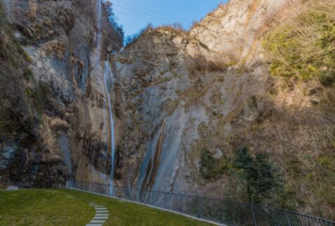
- Davine waterfall and Trobiolo waterfall
- Cycle path on the tree-lined bank of the Oglio river
- Via Valeriana, with a panoramic view of the valley from Pizzo Badile to Lake Iseo
- Rural buildings: on the plain, the former house of Mauri brolo; on the slopes of the mountain along the via Valeriana and the via delle vigne, casa Belocc, casa Saloni, cadèi (small rural structures)
- Rock graffiti from the Celtic and Roman ages, from the Davine valley to the Trobiolo valley, above and below the Via Valeriana
- Country church of Saints Cosma and Damiano, located near the convent of the Annunciata, mentioned in a 14th-century document
- Convent of the Annunciata with two precious cloisters and church with frescoes by Pietro da Cemmo, built in the second half of the 15th century
- Letari restaurant, in a panoramic position at the Annunciata, active since the early 1950s
- Church of San Vittore, of which we have news from a document dating back to the XII century
- Church of the Immaculate Conception – Sant’Eustachio, from the beginning of the 18th century
- Church of San Filippo Neri, from the 17th century;
- House in Via Monte Grappa 5, (now owned by Cantine Bignotti), built starting from the 14th century;
- Borgo Glazel, a group of buildings arranged around a large rectangular courtyard, erected in the second half of the 19th century; a 16th century building is incorporated, on the wall of which there is a fresco, made in the 19th century, representing a popular festival.
- Former Glazel-Passerini hotel, from the 17th-18th century
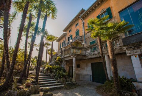
- The Art Nouveau Villa of the lawyer Maffeo Gheza, from the 17th century
- The 20th century lodge of the lawyer Maffeo Gheza with shapes inspired by Arab and Spanish architecture.
- The “Ottone Penzig” Garden inside the park of the lawyer Maffeo Gheza (now owned by Cantine Bignotti)
- The Lanzato wine cellars in via Montello 1 (now Cantine Bignotti cellars)
- Casa Vegezzi (now Gheza, Bondioni, Bruna), 19th century
- Casa Gerosa and then Mauri (now Nodari), with a 17th century portico
- Casa Dabeni, with paintings inspired by A. Manzoni’s The Betrothed, 19th century
- Casa Magnoli, with a structure that recalls seventeenth-century
- Venetian architecture Borgo Olcese (Cogno), a model of an early 20th century industrial settlement
- The Black Madonna along the mule track called via Volte which goes up from Via Monte grappa